

- Date
- 2026년 10월 05일
This post is also available in: 简体中文 (중국어 간체) English (영어) 日本語 (일어) ไทย (태국어) ພາສາລາວ (Korean) Topographic Survey & UAV LiDAR Data Acquisition LaoEarth conducted […]- Date
- 2026년 08월 24일
This post is also available in: 简体中文 (중국어 간체) English (영어) 日本語 (일어) ไทย (태국어) ພາສາລາວ (Korean) Some of our recent activities for GNSS Survey Work […]- Date
- 2026년 08월 24일
This post is also available in: 简体中文 (중국어 간체) English (영어) 日本語 (일어) ไทย (태국어) ພາສາລາວ (Korean) River Cross-Section & Longitudinal Profile Survey Bathymetric & River […]
This post is also available in:
Topographic Survey & UAV LiDAR Data Acquisition
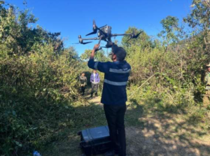
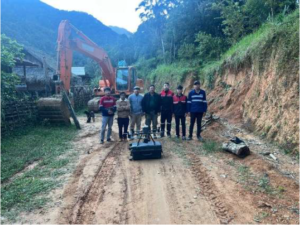
LaoEarth conducted a high-precision topographic survey and UAV LiDAR data acquisition using advanced aerial and ground-based geospatial technologies. The survey integrated DJI M300 RTK, DJI Zenmuse L1 LiDAR, CHCNAV AlphaAir 450 LiDAR, GNSS surveying, and RTK positioning to capture accurate terrain and surface information across the project area.
Survey Control & Georeferencing
During the UAV survey, a DJI ground base station was established to provide RTK correction data to the drone, enabling accurate positioning and georeferencing of the acquired LiDAR and photographic data.
The survey control network was established using GNSS observations and referenced to the applicable national geodetic coordinate framework, allowing the UAV-derived data to be consistently aligned with ground survey measurements and other geospatial datasets.
This approach provides a reliable spatial reference for the production of topographic maps, point clouds, digital terrain models, digital surface models and 3D terrain representations.
UAV Photogrammetry & Image Acquisition
Aerial imagery was acquired using a DJI M300 RTK platform over the project area.
Survey Parameters:
- UAV: DJI M300 RTK
- Flight altitude: Approximately 100–120 m above ground level
- Flight speed: Approximately 6 m/s
- Forward overlap: 80%
- Side overlap: 70%
- Survey width: Approximately 200 m
- Camera resolution: 20 MP
- Maximum flight time: Up to 31 minutes under specified conditions
- Positioning: RTK / GNSS
The selected flight parameters and image overlap were designed to provide sufficient image coverage and redundancy for accurate photogrammetric processing and 3D reconstruction.
UAV LiDAR Acquisition
The project utilized DJI Zenmuse L1 LiDAR together with CHCNAV AlphaAir 450 LiDAR technology to capture high-density three-dimensional spatial data.
LiDAR acquisition provides detailed information about terrain and surface features and is particularly suitable for areas with complex topography, vegetation and other conditions where conventional photogrammetry may have limitations.
The resulting point-cloud dataset can be processed to generate:
- Classified point clouds
- Digital Terrain Models (DTM)
- Digital Surface Models (DSM)
- Contour maps
- Elevation data
- 3D terrain models
- Orthophoto maps
- Survey-grade geospatial datasets
GNSS & RTK Survey Control
Ground control and verification surveys were conducted using dual-frequency geodetic GNSS receivers.
Survey methods included:
- GNSS Static Survey
- Fast Static Survey
- Real-Time Kinematic (RTK) Survey
- Ground Control Point (GCP) establishment
- Check-point measurement and accuracy verification
The GNSS equipment records observations from multiple satellite positioning systems, supporting accurate determination of survey coordinates and providing a reliable control framework for the UAV and LiDAR datasets.
Integrated Survey Workflow
The combination of GNSS, RTK, UAV photogrammetry, LiDAR and ground-based survey control creates an integrated geospatial workflow from field data acquisition to final 3D mapping products.
GNSS Control → UAV RTK Flight → LiDAR & Image Acquisition → Point Cloud Processing → Georeferencing → Accuracy Verification → 3D Mapping & Digital Terrain Products
This integrated approach enables LaoEarth to efficiently transform physical terrain into accurate, high-resolution digital geospatial information for engineering, mining, construction, land development, property and infrastructure applications.
Drone photogrammetry and Drone Lidar Survey